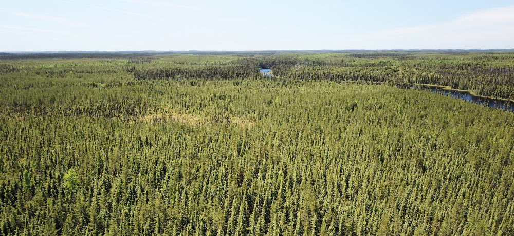
At the start of 2021 AuRista Exploration acquired an option agreement for a 100% interest in the Urban Barry property. Our property is situated in Belmont Township, in the Eeyou-Istchee-Baie-James region of northern Québec, 220 km northeast of the largest regional city, Val-d’Or, 100 km east of the small town of Lebel-sur-Quévillon. The Property consists of twenty “CDC” Claims with a combined total land area of 1127.4 Ha.
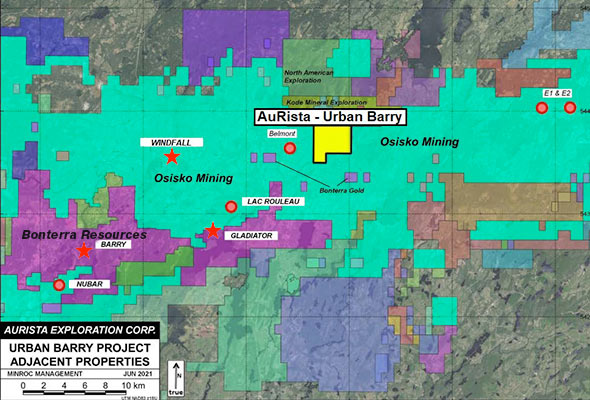
AuRista Urban Barry claims map.
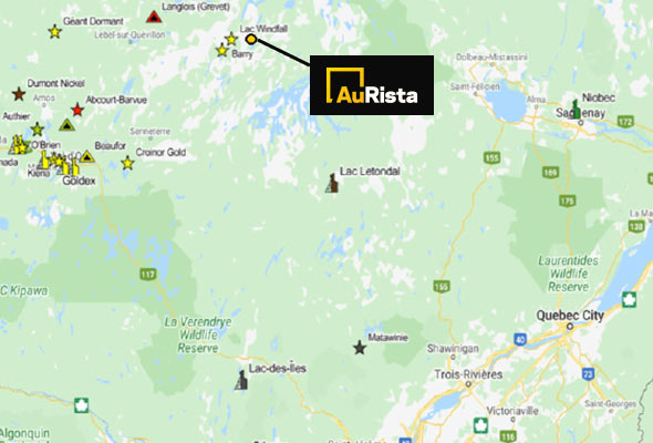
Urban Barry location in Quebec.
Flagship Property
Urban Barry Highlights
Urban Barry
Exploration
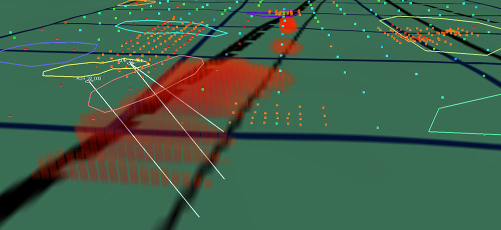
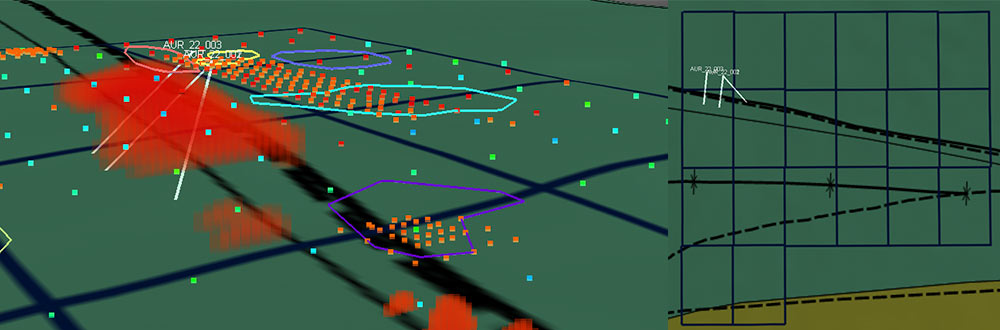
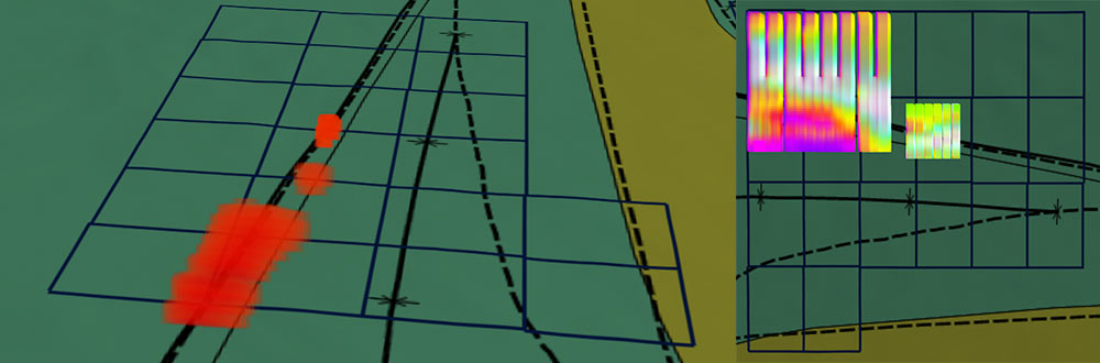
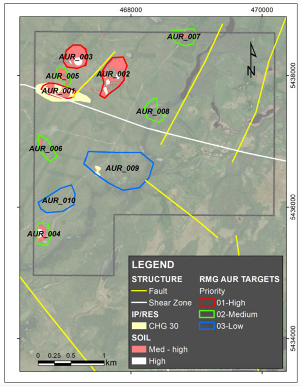
The targets for the upcoming drill program were selected based on the integration of structural interpretation, geophysical and geochemical data. The criteria included structural analysis, induced polarization interpretations and soil sampling anomalies. Spatial overlap of the three criteria resulted in the identification of 10 target areas ranked high, medium or low based on the presence of three, two or one of the determined criteria (figure 1). Thus, combined soil anomalies (for Au, Ag, Mo and Sb) overlapping IP anomalies in proximity to the regional UDZ is considered as the best target for further investigation.
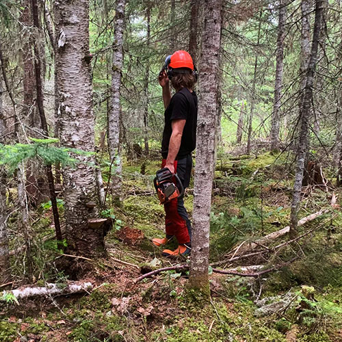
AuRista is planning to conduct a diamond drill program on the Urban Barry property in 2023 post-IPO. The program will focus on high priority zone #001, with current targeting having identified three high-potential drill holes. The holes will be drilled from the north entering at a 45 degree dip striking South, South West, and South East respectively, with the aim of crossing the shear zone and associated IP anomalies. The total length of each hole is estimated to be 500 metres, with further interpretation still required. Final hole selection will be determined following a site visit to assess ground conditions, topography, land access and presence of water.
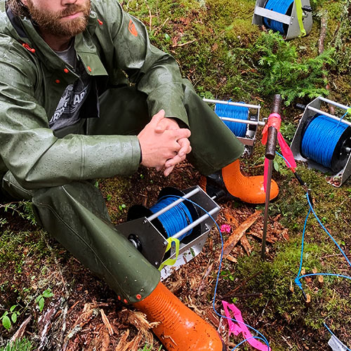
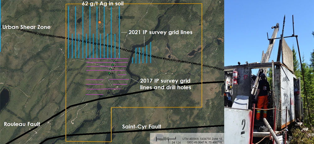
From May to July, 2021, an Induced Polarization (IP) survey consisting of 2 grids totalling 18.4 line kilometres was completed on the Urban Barry property. The intent of the survey was to test areas with known structures (The Urban Shear Zone) and metal-in-soil anomalies, with the goal of finding zones of anomalous chargeability and resistivity. IP survey’s have proven highly useful in identifying drill targets in the region as they are useful in detecting sulfide minerals which form with gold, and the quartz veins which host the gold.
The IP survey was conducted over 51 days in May-July by Exploration Facilitation Unlimited with a significant contribution to the work completed by AuRista’s founders. The results of the survey yielded large chargeability anomalies consistent with previous geochemical assays and structural controls (The Urban Shear Zone). Overlapping resistivity anomalies were also identified contiguous to the structurally controlled chargeability anomalies.
Due to the commitment of the founding team, the IP survey was extended in order to more fully capture the anomalies identified, while remaining under budget. The founder’s contribution resulted in cost savings of over $140,000, which reduced the total program cost by almost 50%.
IP Survey
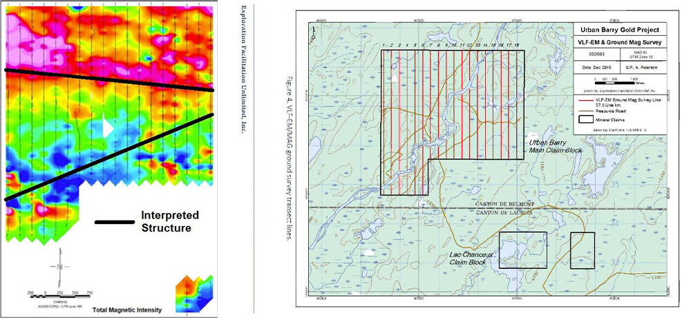
In 2017, six line km of IP surveying were completed. The IP survey focused on a NE-SW striking structure with associated Au in soil anomalies as identified by previous operators. The IP survey execution was hindered by muskeg ground and based on the incompleteness of the survey, was considered to be inconclusive (Peterson 2018).
The induced polarization survey was performed between June 13th and 19th, 2017 by Exploration Facilitation Unlimited, Inc. A pole-dipole array, with an electrode spacing (a) of 25 metres, and eight dipole separations (n=1, 2, 3, 4, 5, 6, 7 and 8) was used. Steel electrodes were used at the receiver and the transmitter. The survey was able to identify 3 chargeability-high zones which formed the basis for the ensuing drill program.
Drill Program
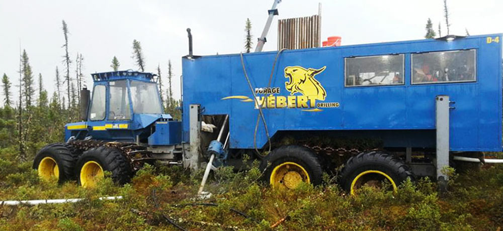
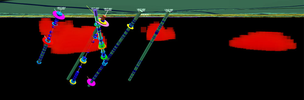
Immediately following the June IP program, Forages Rouillier of Amos, Qc. was contracted to test drill the apparent anomalies from the 2017 IP survey. The drill arrived about 6km from the drill sites on a low bed on the 21st of June 2017 and was mobilized to the same landing for transport away on the 7th of July. The EFU crew, final samples, and camp were demobilized on the 8th of July. Samples were all delivered to ALS Labs in Val-d’Or Quebec for analysis.
The drilling was completed on five (5) holes with depths varying from 189m to 364m for a total of 1,372m. Holes were all drilled from the main road on the west side of the claims near a junction with the main access road used for this program. The five collars span a distance of 350m along the road with four of the holes drilled to the east and the 5th and final hole drilled to the SSE.
All core samples were split with a hydraulic splitter and bagged and tagged at the EFU camp—the site of the core shack and all core processing. The splitting area and cutter were cleaned after each sample to avoid potential cross-contamination. Samples were placed in clear plastic bags with the sample number written on the outside of the bag. A paper tag from the lab was then inserted in the bag before sealing the bag with a zip tie.
533 samples including 507 drill core, 12 duplicates, 5 blanks, and 9 standards were collected from the Urban Barry drill core logging program and they were submitted to ALS labs in Val d’Or for analysis in four (4) batches. Sample deliveries were made to the lab on June 26th (187 samples), June 30th (142 samples), July 6th (141 samples) and July 10th (62 samples). A final load of four samples was submitted to Activation Labs in Ancaster, Ontario on February 14th, 2018.
At ALS samples were crushed to 70% passing <2mm before being split with a riffle splitter. The split was then pulverized to 85% passing <75μm before analysis. 50g samples were analyzed for Au by fire assay with an AAS finish in addition to the multi-element aqua regia ICP-AES analysis.
The drill program tested IP and conductive anomalies which were interpreted to represent the confluence of the Rouleau Fault with the Urban Deformation Zone in the centre of the Property. The most notable gold value returned from this drill program was 0.239 g/t Au over 1 m from hole UB17-001. Modest zinc mineralization was encountered by UB17-002 which returned an interval of 0.54% Zn over 1.1 m from sphalerite-bearing chloritic basalts.
VLF & Ground-Mag
In the summer of 2016 Aldever completed ground magnetics and VLF-EM surveys across the majority of the Urban Barry Property, on north-south lines with 200 m spacing (coming to 57.6 line km) and 12.5 m reading separation. A stark contrast in magnetic relief was noted on either side of a broadly east-west contact traversing the north-centre of the Property; this was taken to delineate the Urban Deformation Zone or its southern contact. VLF anomalies were interpreted to delineate sulphidic zones within intermediate volcanics in the southern half of the Property.
Beep Mat
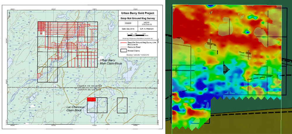
A Beep Mat survey is used to detect magnetic susceptibility and relative EM conductivity. In 2016 EFU completed an 89.3 line-km beep mat survey over a N-S and E-W grid. Challenging ground conditions prevented the entire property from being surveyed. The program succeeded in finding some anomalies which were used as targets for Shaw “backpack” drilling.
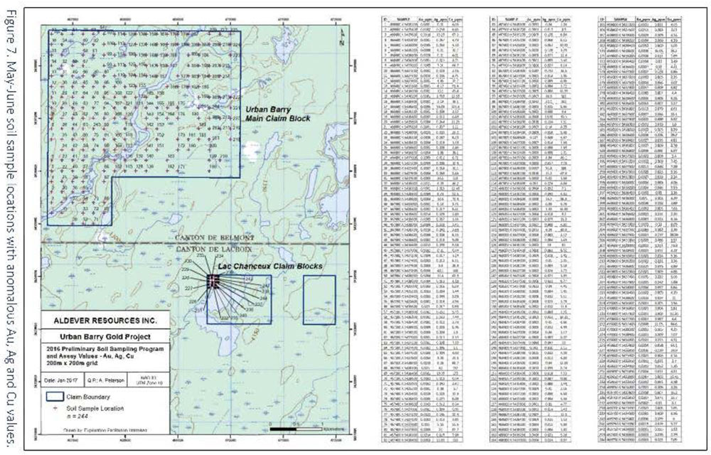
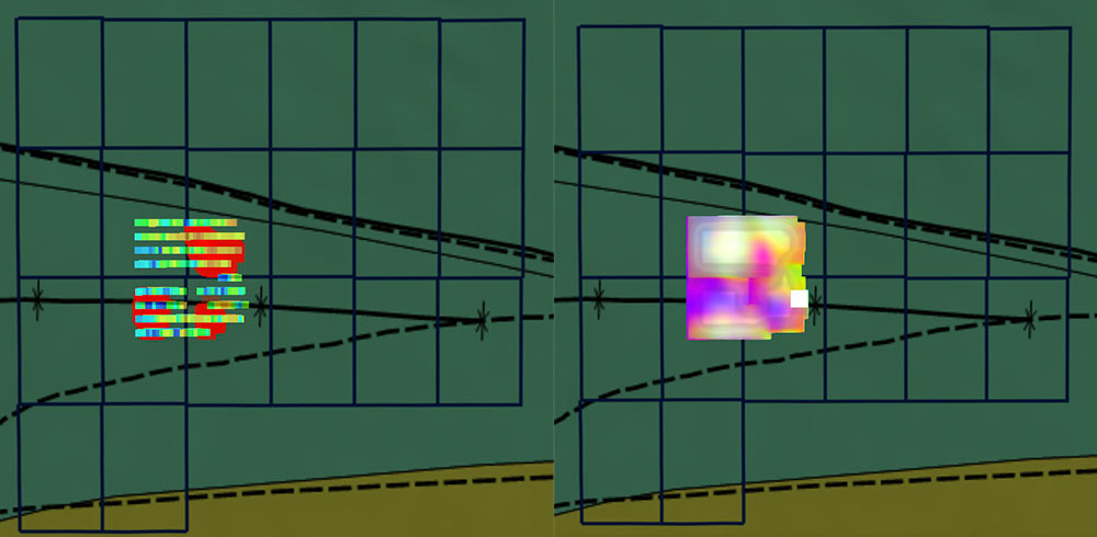
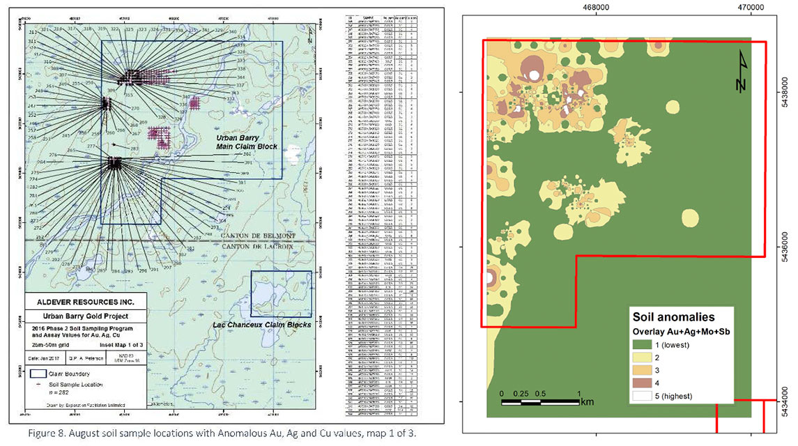
The 2016 soil samples were reevaluated, recontoured and combined through a raster overlay analysis to obtain those areas where Au, Ag, Mo and Sb anomalies overlap. The overlay analysis yielded five areas with highest potential to host Au mineralization in the subsurface, four of them within the Urban Formation in proximity to the UDZ or to second order north-northeast-trending interpreted faults, and one anomaly within the Macho Formation. The second highest anomalies occur in the Urban and Macho formations, including the area drilled in 2017. The anomalies with highest potential, which are located in the northwestern quadrant of the property, were simplified into three main areas more favorable for gold mineralization. Copper anomalies cluster in the northwest quadrant as well and are spatially related to the areas of highest potential for Au mineralization. Lead anomalies occur on the northeast and southern areas of the property unrelated to precious metals and overlapping As anomalies. Zinc anomalies overlap either Ag or Pb anomalies.
Urban Barry
Property Information
The Urban Barry Property lies within the Urban Barry Greenstone Belt, which lies in the northeast of the Abitibi Subprovince, a component of the Superior Province of the Canadian Shield. The belt is late Archean in age, strikes for about 200 km east-west and consists of suites of mafic to felsic volcanic units, with intrusives and sedimentary sequences, all generally trending east-west with a subvertical dip. From north to south, the Property is underlain by the Urban Formation, Macho Formation and Chanceux Formations, all of which have varied makeup but are predominantly thick mafic flow sequences. The formations are all in faulted contact, with the Urban Deformation Zone and the St-Cyr Fault separating them. Several historic interpretations (e.g. Cloutier & Lapointe 1999, Peterson 2018) show northeast-striking, probably younger faults crossing the Property.
The Authors consider that the orogenic gold model is the most appropriate model for exploration on the Property. Orogenic gold, or greenstone-hosted gold deposits generally consist of a system of auriferous quartz-carbonate veins, which have a strong spatial association with crustal-scale shear zones with mixed brittle-ductile expression. Further, there is commonly an association with second-order fault structures, porphyritic intermediate or syenitic intrusives and, less commonly, iron formations. In some districts, specific intrusions have been hypothesized to be the original source of the gold-bearing fluids whereas in others, the original gold source is assumed to be some deeper unidentified intrusive or simply the remobilization of gold from the bulk crust.
Orogenic gold deposits are particularly common in Archean-age greenstone belts. The shear zone is generally theorized to act as a pathway for hydrothermal fluids. These fluids are then emplaced as veins in dilated portions of ductile-deformed units, in brecciated portions of more brittle units, or broadly permeated throughout host units to form halos of disseminated mineralization. Common alteration assemblage minerals include sericite, chlorite, carbonates (commonly ankerite), silica, tourmaline, scheelite, and a wide range of sulphide minerals.
One of the first potentially economic discoveries in the region was the Lac Rouleau gold occurrence (about 12 km SW of the Property), where assay intervals of $2.85/tonne gold over widths of 34 feet were reported from trenching in 1938 (Germain 1938). At around the same time, at Lac Chanceux (about 3 km south of the Property), chalcopyrite mineralization in sheared pillowed basalts was uncovered by trenching, which returned moderate Cu and Ag values and low Au values (Freeman 1940).
Following these and other early discoveries, the Québec Department of Mines completed the earliest comprehensive regional-scale geologic mapping and reconnaissance exploration in the area in 1939 (Freeman 1940, Milner 1943). Both authors refer to the paucity of outcrop in the region.
Later on Murgor Resources discovered the Barry gold deposit (about 25 km southwest of the Property) in 1994, west of the Urban Barry property, which was quickly followed by the Alto discovery of the first major gold mineralization in the Lac Windfall area in 1996. The Spartacus occurrence (today called Gladiator) was discovered by Xemac Resources (about 12 km SW of the Property) in 1997 (Rougerie 1997).
Aur Resources then completed a ten hole drill program, situated on the diorite to the west of the Property. Drillhole 13501-10, about 2.7 km west of the Property, returned an interval of 1.7 g/t Au over 0.7 m (Lapointe 1999). In the SIGEOM system this drillhole intercept is listed as the “Belmont” gold occurrence.
Murgor Resources expanded its regional exploration efforts following these discoveries. Murgor and Freewest acquired a wide area covering the northeastern portion of the Urban Barry greenstone belt including the present Urban Barry Property, completing airborne resistivity surveys which overlapped with the Property in 2004. Murgor discovered the Windfall deposit (about 15 km west of the Property) in 2004-05.
The first private regional-scale exploration work was completed by Shell Canada in 1977 who commissioned an airborne magnetic and resistivity survey along 1,524 line kilometres covering an east-west swath along the greenstone belt (de Carle 1977). The results were reviewed and programs of ground follow-up were instigated upon the more promising targets, consisting of ground VLF surveys, geologic mapping and diamond drilling (Cote 1977). A conductive anomaly is noted within the Urban Barry Property boundary on maps in the Cote report, but no groundwork was completed within the current Property. The Shell Canada work was followed by a similar effort by the Québec MERN in 1981 who flew resistivity surveys across much of the greenstone belt, and superimposed the resulting anomalies on aerial photography (Gobeil 1983).
In the 1980s the Urban Barry claims overlapped with a joint venture property held by Masseguay Mines and Oasis Resources (called the Eagle River project). Airborne magnetic and VLF surveys were flown, with ground surveying, mapping and sampling to follow up on selected targets, none of which were within or close to the present Property.
In the 1990s, the claims fell within Aur Resources’ Belmont Property, which was smaller than the previous belt-scale properties, covering about 15 km of strike east-west. Aur Resources completed heliborne magnetic, resistivity and VLF surveys with soil geochemical surveys and geologic mapping. Soil samples were taken from both humus and the B Horizon. Aur’s soil sampling grids overlapped with the current Property with relatively elevated values of 96 ppb Au reported from a sample about 100 m east of the Property boundary, part of a larger elevated Au trend which was interpreted to follow a northeast-striking fault, possibly the Barry or Rouleau Fault (Cloutier & Lapointe 1999). Another elevated gold trend was interpreted to follow an unnamed northeast-striking structure in the west of the present Property. Aur reports do not present detailed soil sampling data, although Cloutier & Lapoint provide a compilation map showing the locations of elevated soil values. The nearest surface grab sample was taken 900 m east of the Property, close to the trace (inferred by Aur) of the Urban Deformation Zone, and returned 614 ppb Au from sheared, ankeritic sediments and volcanics. Two outcrops of basalt were noted on the east bank of the Rivière St-Cyr in the approximate centre of the present Property. A grid was cut in 1998 and ground IP and magnetic surveys were completed; this grid covered the southern part of the present Urban Barry Property as well as ground to the west to cover a folded diorite structure. A number of IP anomalies were picked in the southern part of the current Property, and Aur interpretations show a tight east-west fold (with its axis running close to the southernmost boundary of the present Property); with the fold nose facing east and offset by northeast-striking faults.
In 2008 after the Murgor-Freewest JV dropped, the current vendor acquired claims in the region, including the Urban Barry Property. In 2015 and optioned the claims to Aldever Resources in 2016, who completed a property wide soil sampling, ground magnetics, induced polarization, followed closely by a 1300 metre drill program.
An IP survey is primarily used to detect two things in a rock mass under the surface: chargeability and resistivity. The survey is carried out by sending an electric current into the ground through a transmitter pin which is received by multiple receiver pins equally spaced along a grid line. Highly sophisticated transmitter and receiver equipment are able to interpret the amount of current received by the pins and this data is used to determine the chargeability and resistivity of the rock. The chargeability can detect the presence of sulphide minerals which are often associated with gold mineralization. The resistivity measure is effective at detecting the presence of quartz veining which can potentially host gold mineralization.
“IP surveying has proven to be the most useful geophysical technique in the Urban-Barry Volcanic Belt.” – Pg. 40 NI 43-101 Technical Report Preliminary Economic Assessment (PEA) Barry Gold Project, Quebec, Canada, Metanor Resources Inc.
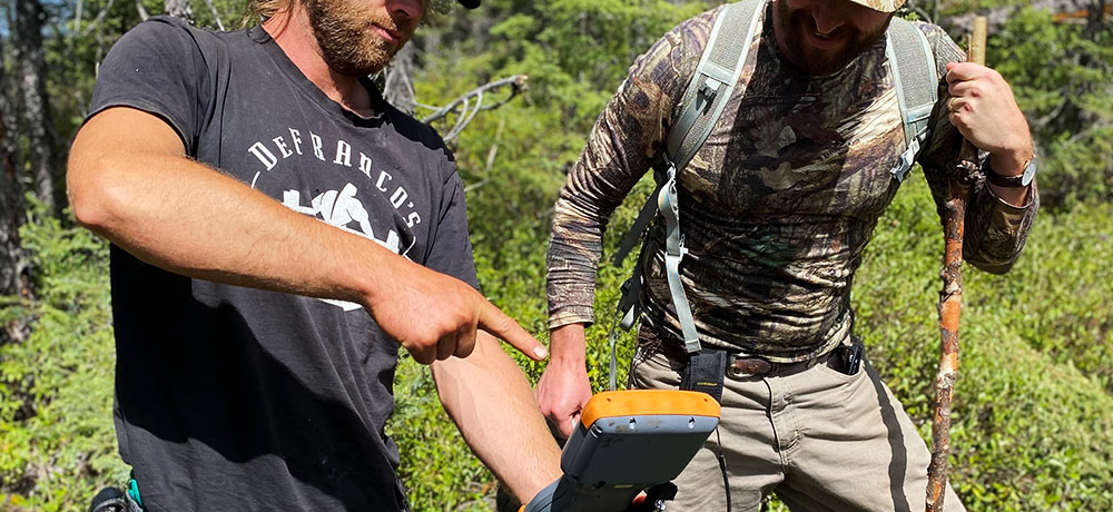
In general, within the Abitibi greenstone belt, there is a large amount of swampy overburden and very little rock outcrop. It is not uncommon for the overburden to reach up to 30m in depth, rendering prospecting, rock sampling and mapping ineffective. That is why many of our neighbouring companies have used early-stage methods such as soil sampling and till sampling to define regions of potential followed by geophysics to identify areas of high potential for drilling.
- 2021 NI 43-101 TECHNICAL REPORT on the URBAN BARRY PROJECT (Available upon request)
- La Grande Alliance treaty with the Cree Nation
- Plan Nord initiative
- Quebec super flow
- Economic stability and overall positive sentiment towards mining companies and their operations
This websites technical aspects have been reviewed and approved by Brian H. Newton, PGeo (PGO# 1330), a Qualified Person, as that term is defined under National Instrument 43-101, of Minroc Management Limited, is a consultant for Aurista Exploration Corp.